FEMA Updates to Flood Risk Maps in Mendocino County and the City of Ukiah
In 2020, the Federal Emergency Management Agency (FEMA) initiated a multi-year project to revise flood maps for Mendocino County and the City of Ukiah. On August 16, 2022, FEMA shared a presentation that included preliminary Flood Risk maps. The preliminary maps identified a significantly expanded flood risk area for the City of Ukiah. On March 15, 2023, Ukiah Mayor Mari Rodin, on behalf of the City of Ukiah and Ukiah City Council, submitted an appeal of the preliminary flood maps to FEMA through Congressman Jared Huffman’s office. The City’s appeal was based on local hydraulic and hydrologic studies conducted by the City, and shared with FEMA, of the Orrs Creek, Doolin Creek, Gibson Creek, and other area tributaries.
In response to the City’s appeal, FEMA released a revised (2024) proposed flood map with minor revisions to a floodplain area in the Mendocino County unincorporated area. After submitting additional comments to FEMA on September 30, 2024, the Ukiah City Council directed the preparation of hydraulic and hydrological studies and further collaboration with FEMA.
On September 19, 2025, the revisions to FEMA documents will become effective.
Flood Risk Mapping
FEMA Flood Risk Mapping requires close coordination between FEMA and local flood control agencies. FEMA utilizes local flood data, as well as their own data and analysis, to develop flood maps, also known as Flood Insurance Rate Maps (FIRMs), and a Flood Insurance Study (FIS). Any properties identified with a 1% chance or higher of experiencing a flood each year are considered high risk and will be designated Special Flood Hazard Areas (SFHAs).
When FEMA’s flood maps are revised, additional properties may be identified in the SFHA as compared with previous flood maps. Properties within the SFHA may be subject to more stringent building standards and/or insurance requirements. Properties identified in the SFHA with mortgages from government-backed lenders are required to have flood insurance.
Finalized Panels & Studies
The finalized Flood Insurance Rate Map (FIRM) Panels and Flood Insurance Studies (FIS) for the City of Ukiah reflect the results of FEMA’s multi-year flood hazard mapping effort. These documents are required tools for managing flood risk, guiding development, and determining flood insurance standards.
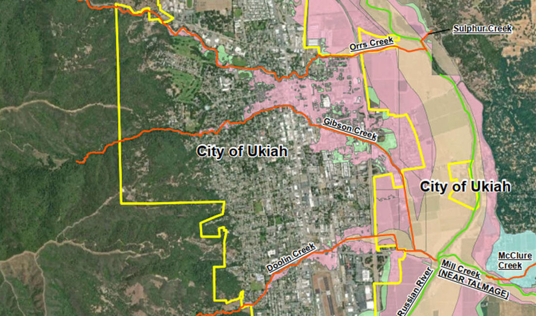
FIRM Panels are the individual map sheets that make up FEMA’s official Flood Insurance Rate Map (FIRM) for a community. Each panel shows flood zones, base flood elevations (BFEs), floodways, and other information used for flood insurance, building permits, and risk communication. See below for the finalized FIRM Panels for the City of Ukiah effective 09/19/25:
- All FIRM Panels
- FIRM Panel 1518 (Western Ukiah)
- FIRM Panel 1518 (Talmage)
- FIRM Panel 1511 (Northwestern Ukiah)
- FIRM Panel 1512 (Northern Ukiah)
- FIRM Panel 1513 (Southwestern Ukiah & Unincorporated)
- FIRM Panel514 (Central Ukiah)
Flood Insurance Study (FIS) are FEMA’s technical report that explains how the official Flood Insurance Rate Maps (FIRMs) were created. It documents the flood sources studied, the engineering methods used, and the resulting Base Flood Elevations (BFEs) and floodway limits that communities must use for regulation. The recent Flood Insurance Study updates for Ukiah are included below:
For More Information
Flood Mapping, Letters of Map Amendment/Revision, and Insurance: contact the FEMA Mapping and and Insurance eXchange (FMIX) at 1-877-336-2627, by Email at FEMA-FMIX@fema.dhs.gov, or visit the FEMA FMIX website.
Ukiah Hydrologic and Hydraulic Studies: contact Tim Eriksen, City Engineer/Public Works Director, at teriksen@cityofukiah.com or 707-463-6280.